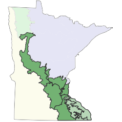
The Minnesota and Northeast Iowa Morainal Section (MIM) is a long band of deciduous forest, woodland, and prairie that stretches nearly 350 miles (560km) from Polk County in northwestern Minnesota to the Iowa border. Over half of this area consists of rugged to hummocky moraines deposited along the eastern margin of the Des Moines ice lobe during the last glaciation. Another quarter of the area consists of rolling till or basal till deposited as drumlins. Small sand plains occur locally within the moraines. A rather large sand plain, the Anoka Sand Plain, is present north of the Twin Cities metropolitan area. This level plain is formed from sand deposited by meltwater from the Grantsburg sublobe, a spur of ice emanating from the east flank of the Des Moines lobe.The presettlement pattern of upland vegetation in the MIM reflects substrate texture and landform topography. These features affected plants directly through their influence on moisture and nutrient availability, insolation, and local temperature, and also indirectly through their influence on the frequency and severity of fires. Sandy flat areas were dominated by prairie, savanna, and oak and aspen woodlands. This is especially true of the Anoka Sand Plain and sandy terraces along the major rivers. In these areas, droughty soils and absence of impediments to the spread of fire promoted fire-dependent prairie and woodland vegetation. A large area of prairie, savanna, and oak woodland was also present on gently undulating glacial till in the southern part of the section, adjacent to the extensive prairie lands of western Minnesota. The low-relief landscape in this part of the section afforded few impediments to the spread of fire, including fires that spread into the section from the adjacent prairie region. Woodland and forest dominated sites in the section where fire was uncommon or rare. Fine-textured drift deposited in hummocky moraines supported mesic forests dominated by sugar maple, basswood, American elm, and northern red oak. Even small reductions in fire frequency afforded by streams, lakes, or topographic breaks permitted the formation of forest on finer-textured soils, and once formed these forests were highly resistant to burning.Floodplain and terrace forests were present historically along the valleys of the major rivers, the Mississippi, Minnesota, and St. Croix, and are still prominent today along many stretches of these rivers. Forests of silver maple occupy the active floodplains, while forests of silver maple, cottonwood, box-elder, green ash, and elm occupy terraces that flood infrequently. These valleys are also characterized by herbaceous and shrubby river shore communities along shorelines and on sand bars, and in some areas by cliff communities on steep rocky river bluffs. Closed depressions that pond water in the spring provide habitat for open wetlands such as marshes, wet meadows, shrub swamps, and wet prairies. Peatlands are uncommon in the section and usually develop following formation of sedge or moss mats over sediments in former lake basins.

Subsections are units within Sections that are defined using glacial deposition processes, surface bedrock formations, local climate, topographic relief, and the distribution of plants, especially trees. Minnesota has 26 subsections. Printable map of subsections