A monthly electronic newsletter summarizing Minnesota's climate conditions and the resulting impact on water resources. Distributed on the first Thursday of the month.
State Climatology Office - DNR Division of Ecological and Water Resources, St. Paul
distributed: July 13, 2023
What happened in June 2023:
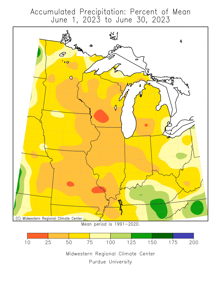
- June 2023 was the third June in a row to be drier than normal statewide. The very few exceptions were some locations in the north central, the northeast and a small part of southwest Minnesota. Many locations in east central and southeast Minnesota finished three inches short of normal for the month or greater. The Twin Cities had .93 inches for June 2023, 3.65 inches short of normal and the second driest June total out of 153 years with precipitation records. Rochester had 1.34 inches, or 4.01 inches short of Normal. Warroad in Lake of the Woods County was one of the wettest locations with 7.09 inches of precipitation for the month. The preliminary statewide average total was 2.35 inches or 2.36 inches short of normal.
[see: June 2023 Precipitation Total Map | June 2023 Precipitation Departure Map | June 2023 Climate Summary Table | June 2023 Percent of Normal Precipitation Map] - There was one severe weather event of note in June 2023. Welcome rains, and not-so-welcome tornadoes hit the state during the weekend of June 23-25. Most of Minnesota received a half-inch of rain or more, though parts of northwestern, central, and northeastern Minnesota received 1.5 to 3 inches of rain. The heaviest rains fell in in the Island Lake area, northwest of Duluth, where two CoCoRaHS observers reported 4.89 and 4.32 inches. Observers southwest of Brainerd, and also north of Hawley in northwestern Minnesota reported at least three inches of rain. The least rain fell in far west-central and far southeastern Minnesota, where observers reported a quarter-inch of rain or less. There was also a swarm of mostly small and relatively short tracked tornadoes in Becker, Norman, Mahnomen and Polk Counties of northwest Minnesota. There was damage to a barn two miles to the east-southeast of Mahnomen.
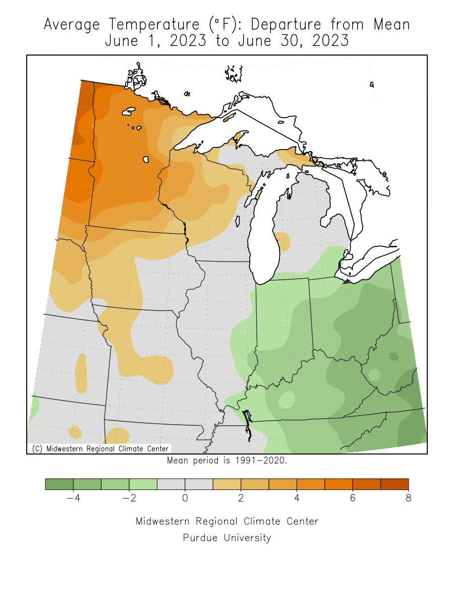
[see: Needed Rain (and Not-Needed Tornadoes)] - June 2023 was the 4th warmest June on record statewide. This was the third June in a row with above normal temperatures. June 2021 was the third warmest on record. The preliminary June average temperature was 69 degrees, or 4.2 degrees above normal. The warmest temperature reported in Minnesota was 98 degrees at Hallock Minnesota on June 21 and the coldest was 24 degrees at Ely in northeast Minnesota on June 11.
[see: June 2023 Climate Summary Table | 2023 June Departure from Normal Temperature Map]
Where we stand now:
- Seasonal precipitation so far (April 1 through July 11) shows a mostly dry state with a few pockets of above normal precipitation. The driest areas are along the Iowa border and a wide area across central Minnesota. Some locations in central and far southwest Minnesota have only about half the precipitation to July 11 compared to normal. The wettest area is in a pocket in southwest Minnesota that saw the heavy rains back in mid-May. Parts of Brown County are in the 80th percentile.
[see: Seasonal Precipitation Maps] - The U. S. Drought Monitor map released on July 13 depicts 11% of the state in Severe Drought 52% of the state in Moderate Drought conditions and 36% of the state in Abnormally Dry conditions. One year ago at this time 90% of the state was free of any drought designation. The U.S. Drought Monitor index is a blend of science and subjectivity where drought categories (Moderate, Severe, etc.) are based on several indicators.
[see: Drought Conditions Overview] - The U.S. Geological Survey reports that stream discharge levels vary quite a bit in the state, ranging from normal to much below normal. The majority of streams are in the “below normal” range with a growing number in the much below range.
[see: Cooperative Stream Gauging | USGS Stream Flow Conditions] - Water levels on Minnesota lakes vary depending on lake and location in the state. On July 11, Minnetonka was at 928.57 feet and Gray's Bay Dam is now closed. White Bear Lake was at 922.70 feet, a fall of about one foot from July 2022. The level of Rainy Lake was in the median band, however the net inflow and outflow was below the median. Lake of the Woods fell below the median band in early July and continued a downward trend through July 13. Lake Superior was at 602.62 feet on July 7, six inches above the long term monthly July average.
[see: Mille Lacs Lake Water Level | Lake Minnetonka Water Level | White Bear Lake Water Level | Lake of the Woods Control Board Basin Data | Corps of Engineers Great Lakes Water Levels] - The Agricultural Statistics Service on July 10 reported that topsoil moisture across Minnesota is 12 percent Very Short, 42 percent Short, 45 percent Adequate, and 1 percent Surplus. Soil moisture levels at Lamberton on July 1 were close to historical averages, with adequate subsoil moisture but the top foot was very dry.
[see: Agricultural Statistics Service Crop Progress and Condition | U. of M. Southwest Research & Outreach Center (Lamberton) | 2011-2018 Lamberton Soil Moisture Graphs ] - Spring and Summer 2023 has seen some elevated fire danger at times. Cooler weather eased the danger somewhat for the second week of July. The potential for wildfires is currently rated by DNR Forestry as Low across much of western and east central Minnesota, with Moderate fire danger over the southeast, central and northern Minnesota.
[see: Fire Danger Rating Map]
Future prospects:
- The July precipitation outlook has equal chances of above, normal and below normal precipitation, except in the far southwest where there is a slight tilt for above normal precipitation. July precipitation normals range from just under three inches in northwest Minnesota to about five inches in southeastern counties.
[see: Climate Prediction Center 30-day Outlook | July Precipitation Normal Map] - The warm summer continues with July temperature outlook weighted to be above normal, especially in the northern half of Minnesota. Normal July high temperatures are in the 80s in the south and the upper 70s in the north. Normal July low temperatures are in the 50s in the north, and in the 60s in the south.
[see: Climate Prediction Center 30-day Outlook ] - The 90-day precipitation and temperature outlook for July through September at least according to the Climate Prediction Center, there are equal chances of above normal and below normal temperatures for all of Minnesota except the far northeast and southeast, where there is a slight tilt for above normal temperatures. Looking ahead to the winter of 2023-23, there is a strong tendency for above normal temperatures and below normal precipitation.
[see: Climate Prediction Center 90-day Outlook | Dec-Jan_Feb 2023-22]
From the author:
- On June 14, Minnesota had the worst air quality in the county, with the Air Quality Index reaching the Very Unhealthy category. Minnesota has been plagued by smoke from wildfires from Canada in May and June. The latest event had some of the densest smoke move right over the Twin Cities. The Twin Cities International Airport began reporting smoke at Noon on June 14 and reported smoke for 19 hours straight ending at 6am June 15. The sun was reduced to a pale disk in the sky. It even appeared hot pink at 7:30pm June 14 in St. Paul The thickest smoke in the Twin Cities was from 7-9pm on June 14, with visibilities down to one mile and a quarter, giving the evening a gloomy, foggy feel to it. The average Air Quality Index (AQI) for June 14 for the Twin Cities was 175, which is the highest daily average measure recorded in the Twin Cities since Air Quality Index records began in 1980. [see: Smoke Event of June 14, 2023]
Upcoming dates of note:
- July 20: National Weather Service releases 30/90-day temperature and precipitation outlooks